
 »
» Português do Brasil
The LGI


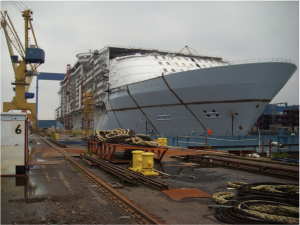 INDUSTRIAL GEODESY (Large Scale Metrology, Large Volume Metrology) is the area of industrial metrology that covers methods and techniques used in the inspection, positioning and alignment of large structures. Industrial geodesy techniques are strategic for sectors such as naval and offshore, aerospace, steel and power generation equipment industries, which are under constant pressure for increasing efficiency and quality of construction and assembly processes for large structures.
Large coordinate measuring machines, photogrammetry systems, multilateration systems, total station, laser tracker, indoor GPS, laser scanner and laser radar are some technologies used in industrial geodesy.
 Founded in 2015, the Laboratory of Industrial Geodesy – LGI has the mission of generating and disseminating knowledge in the field of industrial geodesy, through research and development projects, undergraduate and graduate education, special services, consultancy and training.
The LGI is inserted in the Technology Center Joinville of the Federal University of Santa Catarina and its activities are strongly aligned with undergraduate engineering courses offered in that center, such as Naval Engineering, Aerospace Engineering, Automotive Engineering, Railway and Metro Engineering, Mechatronics Engineering and Infrastructure Civil Engineering, as well as with Graduate Programs in Mechanical Sciences and Engineering and Electronic Systems Engineering.